City layout map
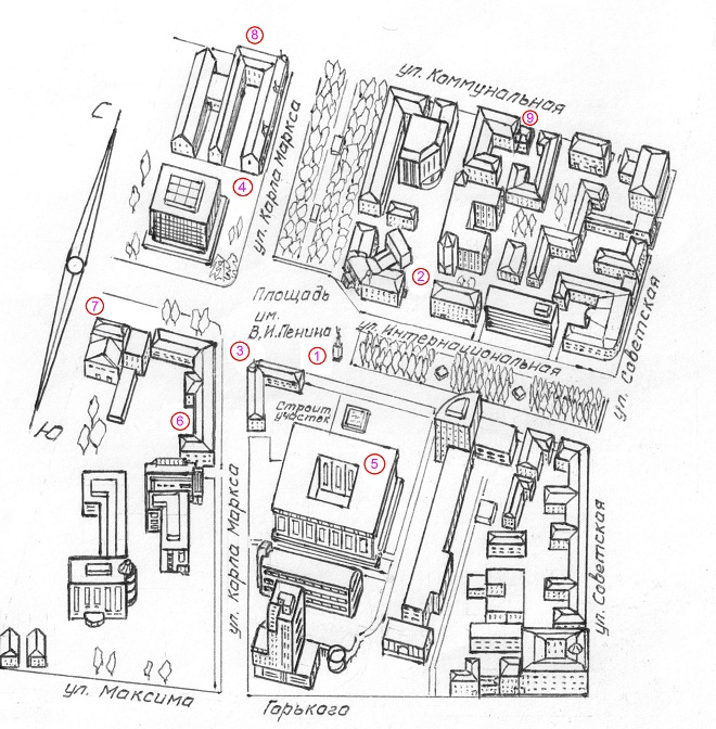
| Layout map of Tambov, 2013. | ||
 |
||
| 1 - Monument of V.I.Lenin, 2 - Tambov drama theater, 3 - Former hotel "Tsna", 4 - Tambov Regional Universal Scientific Library named after A.S. Pushkin, 5-Administration of Tambov region, 6 - Former building of Regional military commissariat, 7 - Cinema theatre "Rodina-Kinomax", 8 - Former house of Shorshorov, 9 - Administration of the city of Tambov. | ||
|
Monument of V.I. Lenin is clearly seen on the image of the Square. It is located in its eastern side. To the north of the monument at the intersection of Karl Marx and the Internationalnaia Streets there is a building of Tambov Regional Drama Theater. It has three facades. The central part of the building faces the Square, and its two perpendicular wings face the above mentioned streets. It is easy to locate the former hotel "Tsna" on the presented map; it is marked with number 4. It is a corner building on the southern side of the Square.
The main administrative building of Tambov region is designated by number 5 on the map. It is located behind the construction site, which separates it from the hotel building. On the opposite side of the hotel down the Karl Marx street there is a building of the former Regional Military Commissariat. Its northern wing faces the Internationalnaia Street. Under number 7, there is a neighboring building (on the western side) of LLC Cinema theater "Rodina-Kinomax." Number 8 indicates the building of the former house and shop of the Tambov merchant M.L.Shorshorov. It is "U" shaped and is located at the intersection of Kommunalnaia and Karl Marx Streets. It is difficult to determine the location of an administration building of the city of Tambov. It is "C" shaped and is located on the southern side of Kommunalnaia street in the middle of the street segment, depicted on the map.
|
||
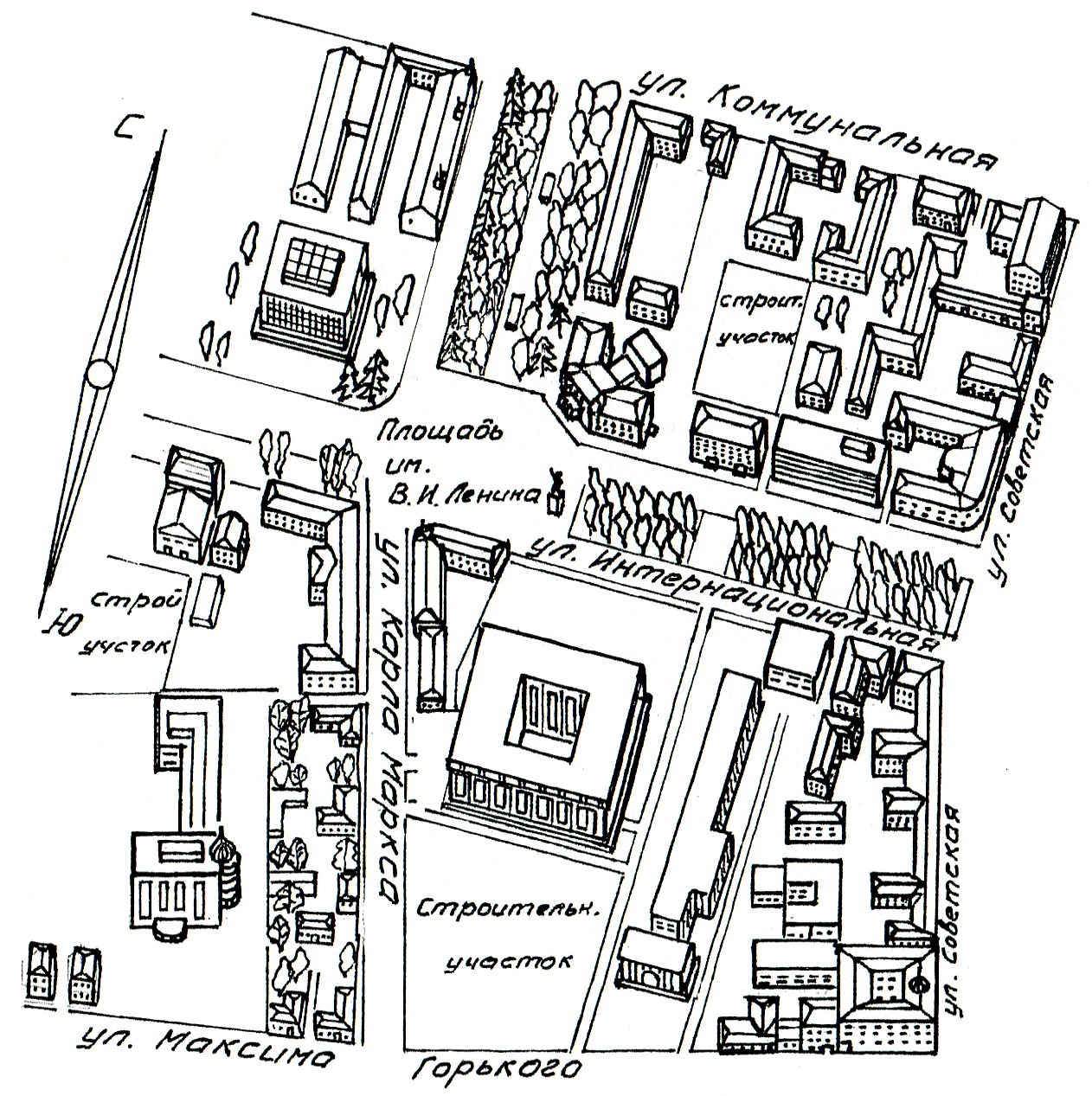
| Layout map of Tambov, 2000. | ||
 |
||
|
Let’s make a comparative analysis of changes in the architectural development of this urban area (the center of Tambov in the area of Lenin Square), which was presented on the previous map (2013). Thirteen years, which separate visual images presented on these maps, left their significant contribution to the architectural ensemble of the considered urban area. Upon closer inspection, we can notice a two-storey old apartment building with a gable roof in the vicinity of the "Rodina" cinema in 2000. This building was in critical condition by the end of the twentieth century and was replaced by the "Arcade" cafe in 2002, which is shown on the map of 2012. On the map of 2000 along the west side of Karl Marx Street up to its intersection with M.Gorkii street, there is a long, narrow strip of private residential single-storey houses with adjoining yard and garden areas. These houses were preserved in the center of Tambov since pre-revolutionary times. Only in the first decade of the XXI century they were demolished and modern style building appeared in their place by 2012. On the map of 2000, at the eastern side of the intersection of Karl Marx and Gorkii Streets, there is a large area marked as a construction site. In the early years of this century there was a group of modern architectural buildings, the main purpose of which can be characterized as shopping and entertainment facilities. On the map of 2012, they are marked as existing.
On the map of 2000, in the north-eastern quarter to the east of the Regional drama theater there is a construction site. At that time the building of "Gazstroi" regional administration was constructed there. Finally, note that there are two separating strips in the square behind the monument of V.I. Lenin along the Internationalnaia Street. In the first decades of this century the fountains that existed there before the beginning of the 80s of the last century will be reconstructed. They were removed, and replaced by the recreational area with the park and benches.
|
||
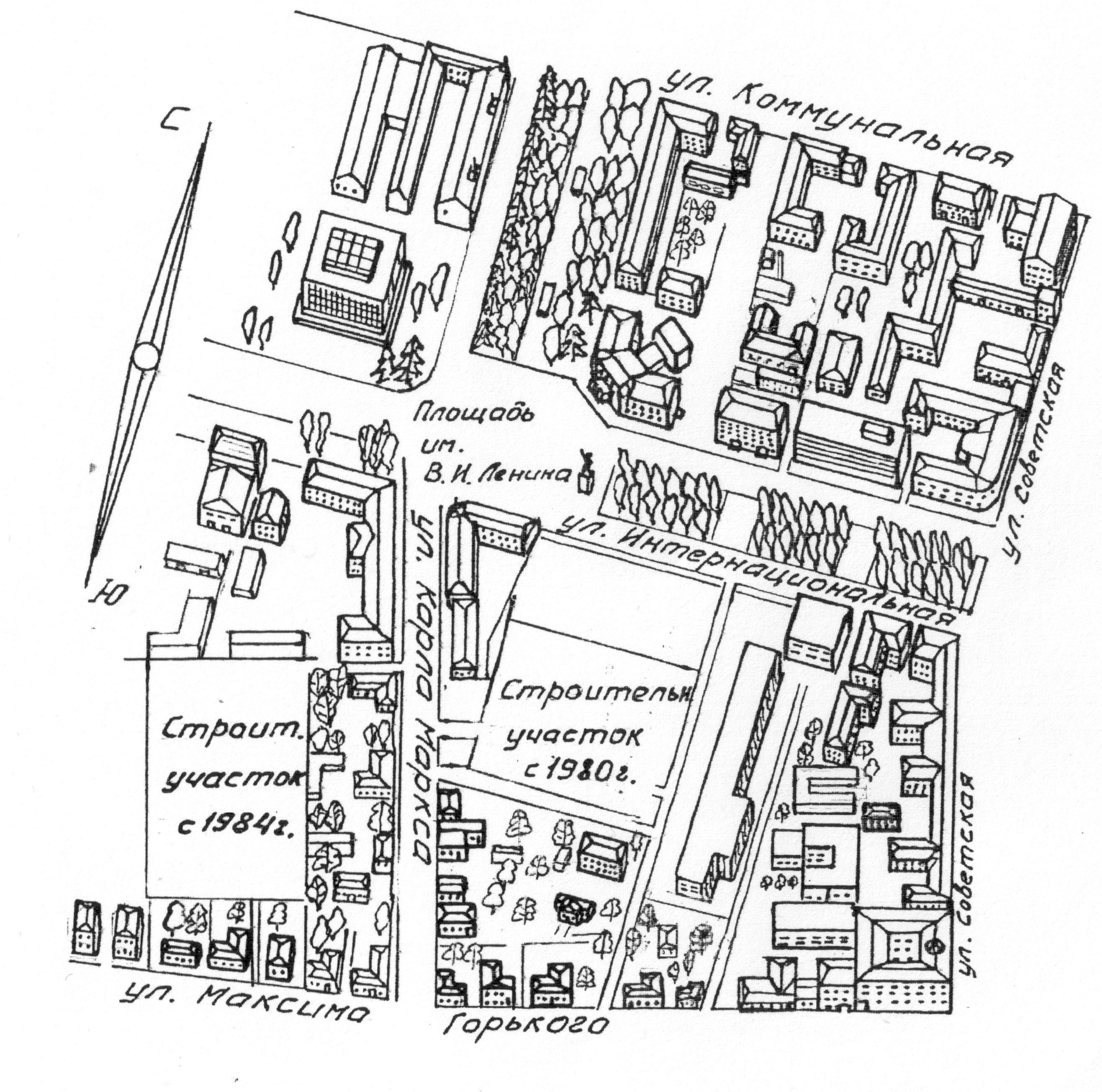
| Layout map of Tambov, 1987 | ||
 |
||
|
The third step in our retrospective analysis of Tambov city center history refers to 1987. Let’s start our analysis of this layout plan of the architectural ensemble of Lenin Square with the south-western area. Here, on both sides of the intersecting streets, there are private houses, which were at this place for more than 100-150 years. By the way, the third house from the corner on Gorkii Street is a house of the famous writer of the XIX century A. Zhemchuzhnikov, where he spent last years of his life. Citizens were going to use this house as a literary museum of the city, but soviet authorities made another decision and the house could not be saved. There is a construction site at this place on the map. By that time, there has been a slow construction of a multi-storey building for the 7th year already, which was planned to be used as a hotel "Intourist". The time has left its adjustments and in the second half of the 90s the building, which was built here, became the Tambov branch of Sberbank of Russia (see. previous map of the year 2000). In the late 80s of the last century at the opposite eastern corner of the Karl Marx and Gorkii Streets there were old (mostly private) buildings. All the buildings: houses, outbuildings and garden plots appeared here in the middle of the XIX century. But closer to the main town square at the end of the 80s an ultramodern building of glass and concrete was being built, which was intended for the regional party committee. This place is indicated by the "Building site since 1980" on the map. In 1987 there was an empty street corner area on Internationalnaia Street between the "AgropromBank" building and the building of the "Central" restaurant. On the northeast quarter behind the State Drama Theatre building there were old houses, which were built in the second half of the XIX century. In Soviet times they hosted numerous administrative urban services. There are other differences on this map compared to the period of 2000s, however, they have no special significance for the formation of an architectural ensemble of the city center. |
Layout map of Tambov, 2013.


